King County’s Flood Warning Center closed on Dec. 30 at 4:55 p.m. now that rivers have receded. During the three weeks of activation staff monitored and patrolled rivers, coordinated emergency actions and repairs with partners, and trained members of the National Guard deployed to provide reinforcements by Gov. Bob Ferguson. For a complete overview of operations and resources, read By the numbers: A look back at King County’s response to historic flooding.
Dec. 18, 2025, 6:41 p.m.
The White River returned to flood phase 4 around 3 p.m. today as water releases from the Mud Mountain Dam have increased. Releases from the dam had been lowered by the U.S. Army Corps of Engineers the last several days. This was to help King County and partners make repairs to flood barriers in the city of Pacific. The higher releases from the dam are necessary to quickly increase flood-storage capacity for incoming storm systems.
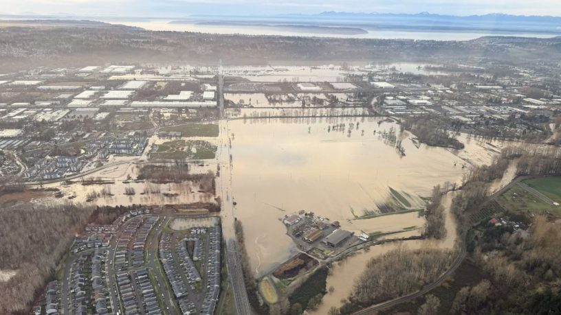
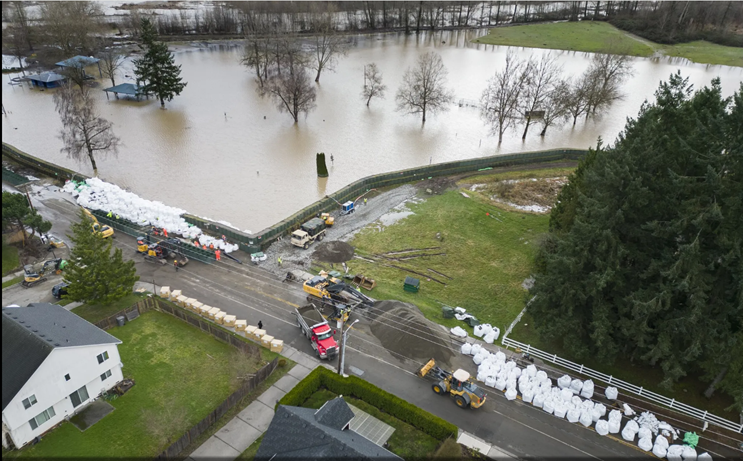
Early in the morning of Tuesday, Dec. 16, floodwater spilled through a double-stacked wall of flood barriers lining the White River through the City of Pacific. This required evacuation of more than 200 homes for safety. We and other emergency responders have been working to reinforce the flood barriers and make improvements to reduce the chance of future breaches.
Flood conditions have held steady on the Cedar and Green rivers, with each river forecast to hold at flood phase 3. Our Flood Patrol crews are still actively monitoring conditions on the White, Cedar, and Green rivers and will be receiving additional support from 10 National Guard members.

Stay informed
Sign up for ALERT King County to stay informed about potential hazards and threats in your area.
You can also track current river levels at flood.kingcounty.gov and visit kcemergency.com for urgent updates and resources.
Safety reminders
- It’s getting colder. Remember, if the power goes out, never use charcoal, gas, or propane heaters indoors, or run a car in a closed garage.
- Do not drive past road closed signs. Turn Around. Don’t Drown. Before you travel, check for updates:
- MyCommute: Road closures and restrictions in unincorporated King County
- WSDOT: Real-time travel across the region
- Metro and Sound Transit service impacts
- Stay healthy: Rainfall and flooding have caused sewage overflows in many areas across King County. Please avoid touching all surface water (including lakes, ponds, streams, rivers, and Puget Sound) at this time.
Flood recovery
We’ve created a one-stop shop to help people safely clean up flood debris: kingcounty.gov/flood-recovery.
You’ll find a complete round-up of resources from across King County government to help you respond and recover from flooding including what to do when entering a flooded home, how to file an insurance claim, and how to dispose of debris and hazardous materials.
Dec. 17, 2025 – 4:15 a.m. update
King County Flood Warning Center: Cedar River reaches Phase 4 flood alert level
The Cedar River has reached the Phase 4 flood alert level from controlled releases at Landsburg Dam east of Renton.
As of 4 a.m. Wednesday, Dec. 17, flows at Landsburg Dam were recorded at 5,060 cubic feet per second, just higher than the Phase 4 flood alert threshold of 5,000 CFS.
There is an extensive list of roads that could be affected by floodwaters when the Cedar River reaches this flood level, including several roads that are the sole access to neighborhoods where residents could become trapped by rising waters. Be sure to check the King County My Commute website for the latest information on road closures.
Elsewhere in King County, the Snoqualmie, Green, and White rivers all remain at Phase 3 flood alert levels, with some flooded roads possible along these rivers, too.
You can track current river levels at kingcounty.gov/flood, and visit kcemergency.com for urgent updates and resources.
Dec. 17, 2025 – 2:15 a.m. update
The Green River has reached Phase 3 flood alert level from controlled releases at Howard Hanson Dam in the Cascade foothills.
Dam managers say releases from the dam help create additional flood storage capacity, and are expected to keep the river high – but stable – for several days.
Meanwhile, the Snoqualmie River remains at a Phase 3 flood alert with some road closures expected into Wednesday. Increased rainfall across eastern King County sent flows along the Snoqualmie River higher.
At 2:15 a.m. on Wednesday, the sum of the Snoqualmie River’s three forks registered at 22,830 cubic feet per second (CFS) – comfortably past the Phase 3 flood alert threshold of 20,000 CFS, and slowly climbing.
Forecasts call for a steady decrease in the Snoqualmie’s flows once Wednesday’s elevated river levels subside. Until that happens, we could see flooding of varied depths across the Snoqualmie Valley, and numerous road closures are likely. Be sure to check the King County My Commute website for the latest information.
Elsewhere, the White River has been holding steady at a Phase 3 flood alert with controlled releases from Mud Mountain Dam expected to keep river levels elevated for several days.
Finally, the Cedar River has been holding steady at a Phase 3 moderate flood flow and was steadily dropping toward minor flood levels.
You can track current river levels at kingcounty.gov/flood, and visit kcemergency.com for urgent updates and resources.
Dec. 16, 2025, 10 p.m.
Additional rainfall across the Cascade foothills has pushed flows in the upper Snoqualmie River to minor flood levels, with the potential for brief impacts to roads and low-lying areas overnight Dec. 16 and early in the day on Dec. 17.
If rainfall intensifies, the Snoqualmie River could rise up to a moderate flood level early by tomorrow morning, with additional flood impacts along the river Wednesday. Widespread flooding is not expected because of this current storm, and river forecasts call for a steady decrease in river levels once Wednesday’s elevated flows subside.
Elsewhere tonight, flows remain high on the Cedar, Green and White rivers because of planned releases from upstream dams. As of 9 p.m. Tuesday, the Cedar River at Landsburg was at a Phase 3 moderate flood flow and was steadily dropping toward minor flood levels.
On the Green River, planned releases from Howard Hanson Dam are expected to hover right around the Phase 3 flood alert level for several days, as managers release water to create more flood storage capacity behind the dam.
Finally, the White River has also dropped into a Phase 3 flood alert level after a long stretch of higher river flows from planned releases out of Mud Mountain Dam southeast of Enumclaw.
As with Howard Hanson Dam on the Green River, Mud Mountain Dam is expected to maintain carefully managed but elevated releases from the dam so there’s enough capacity to store flows in the upper White River watershed for the next storm.
You can track current river levels at kingcounty.gov/flood, and visit kcemergency.com for urgent updates and resources.
Dec. 15, 2025, 8:59 p.m.

Emergency repairs were made this afternoon to a small breach in the Desimone Levee along the Green River in Tukwila. A full week of high flows can saturate levees and leave them weak and susceptible to leaking and other actions. As of this evening, the levee is stabilized from emergency work.
King County is working closely with cities and partners to respond to urgent situations like this levee breach. King County Flood Patrol staff continue monitoring conditions in river basins across the county, having made several emergency repairs on the Green and Cedar rivers and monitoring HESCO flood barriers on the White River.
Additional rain last night and into the morning briefly pushed the South Fork Skykomish River back to Flood Phase 2 and the Snoqualmie River has returned Flood Phase 2 as well. The Cedar and Green rivers have held steady at Phase 3, while the White River remained at Phase 4.
High river levels are likely to continue on the Green, and White rivers for several days as flood control dams in the upper watersheds continue to slowly release stored floodwaters. Residents should stay alert, track changing conditions, and follow official guidance to stay safe.
Track current river levels at kingcounty.gov/flood and visit kcemergency.com for urgent updates and resources. Stay ready and be vigilant.
Flood risks remain – stay alert and follow safety reminders
Dec. 14, 2025, 8:37 a.m.

Flood fighting continues in King County. While many rivers are receding, the Cedar, Green, and White rivers remain at severe and moderate flood phases. Rivers are expected to rise again from late Monday into Tuesday as rain returns to our area. This could cause flooding in urban areas and on small streams and rivers.
The King County Flood Warning Center is open, and Flood Patrols are operating continuously into next week to monitor and respond to conditions on the ground. If you have questions or information to share about flooding near you, please call the Flood Warning Center at 206-296-8200 or 1-800-945-9263.
Safety reminders
- If you are in immediate danger, call 911.
- Stay away from landslides and downed power lines.
- Road safety: Heavy rainfall and flooding have affected many roads and bridges across the county. Before you travel, check for updates:
- MyCommute: Road closures and restrictions in unincorporated King County
- WSDOT: Real-time travel across the region
- Metro and Sound Transit service impacts
- Stay healthy: Rainfall and flooding have caused sewage overflows in many areas across King County. Please avoid touching all surface water (including lakes, ponds, streams, rivers, and Puget Sound) at this time.
Returning to your home or business
- Never turn power on or off yourself while standing in water.
- Do not turn gas back on if your natural gas has been shut off at the meter. Call PSE to schedule a technician to inspect the natural gas piping and relight appliances.
- Open windows and doors and pump out water after flood waters recede. Mold can grow within 24-48 hours after a flood, which can cause health risks.
- When cleaning up, wear rubber gloves and boots, a mask, eye protection, long-sleeved shirts and long pants.
- If you have a flooded private water system or well, only use bottled, boiled, or treated water. If you boil your water, make sure it remains at a rolling boil for at least one minute. Then it is safe to drink.
- If you have a flooded septic system, do not use your septic system, and disinfect it after the flood. When flooding subsides, call a maintainer to check that the flooding did not damage your septic system. See a list of maintainers.
- Always wash your hands with soap before eating.
For more health and safety tips, visit kingcounty.gov/floodrecovery.
Flood damage to your home or business
Property damage caused by flooding can feel overwhelming and stressful. King County’s priority is keeping you safe and supporting your recovery. Visit Emergency News to report damage to your home or business and learn how to file a claim for insurance and with FEMA.
If you live in unincorporated King County, you may need a permit to fix property damage. We’re committed to responding as quickly as possible. This video outlines the steps to take to get a permit to fix property damage as a result of a natural disaster.
Green River returns to Phase 4 after receding, major flooding expected
Dec. 13, 2025, 3:08 a.m.
The Green River has returned to a Flood Phase 4 increasing the severity of flooding. The Green River gauge near Auburn recorded 12,100 cubic feet per second (cfs) at 3:08 a.m., which exceeds the Phase 4 threshold for the Green River of 12,000 cfs.
At this phase, critical flood control levees may weaken from saturation. Sudden changes in flood conditions are possible, especially in levee-protected areas. These changes may include rapidly rising water, widespread inundation, road closures, and utility disruptions.
The King County Flood Warning Center continues to monitor river conditions as a strong atmospheric river moves through our region.
Flood safety reminders
- Stay informed about changing weather conditions by monitoring local weather alerts and updates.
- Track river conditions with free KC Flood Alerts or install the free King County Flood Warning App.
- Review your emergency plan and know your evacuation routes if you live in a flood-prone area.
- Safeguard your property by moving important documents and valuables to a second floor if possible.
- Use sandbags to help protect your home or property. Free sandbag materials are available. Find a sandbag distribution site near you at kingcounty.gov/sandbags.
- Turn around, don’t drown. Never drive or walk through floodwater – 6 inches of water can knock you down, and 12 inches can carry away most cars.
King County Flood Warning Center staff are monitoring stream gauges and weather reports to provide updated information on river conditions as necessary. The Flood Warning Center is staffed twenty-four hours a day, seven days a week during flood events. The center serves as an information clearinghouse for the public and other agencies responsible for ensuring public safety during a flood event. Call the Flood Warning Center during an activation at 206-296-8200 or 1-800-945-9263 to ask questions about current flood conditions.
Stay updated on flood conditions by checking the Keeping King Country Green blog.
Dec. 12, 2025, 9:40 a.m.
The White River has reached Phase 4 this morning continuing to impact the cities of Pacific and Auburn and residents in the Red Creek area.
Residents should be aware of dangerously high velocity and debris flows throughout the river system. Flood waters may overtop SR 410.
Before traveling, check King County My Commute and Washington State Department of Transportation Travel Center Map | WSDOT. Do not drive through flooded or closed roads. Turn around, don’t drown!
The Cedar River remains at Phase 4, the Green River at Phase 3, and the South Fork Skykomish River and Snoqualmie Basin are at Phase 2. The Tolt River and Issaquah Creek are below flood warning thresholds at this time.
Flood phases and sandbag distribution locations can be viewed at kingcounty.gov/Flood.
Be prepared to leave immediately if necessary. Visit kcemergency.com for preparedness information.
Dec. 11, 2025, 2:52 a.m.
After receding for about 12 hours, flows on the Tolt River have increased and the river has reached Flood Phase 3 again. The forecast shows the river continuing to rise for the next several hours this morning.
At 2:15 a.m. the Tolt River near Carnation gauge recorded 5,090 cfs, which is just above the Phase 3 threshold for the Tolt River. Water is possible over sections of Tolt River Rd NE upstream of 6005 Tolt River Rd NE. Increased seepage and potential backyard flooding is possible at the levee on the south bank between Snoqualmie Valley Trail Bridge and SR 203 Bridge.
Stay informed on current conditions at kingcounty.gov/flood. If you have questions or information to share about current flood conditions, please call the Flood Warning Center at 206-296-8200 or 1-800-945-9263.
Four rivers remain at the highest risk level as the White River passes the threshold for Phase 3 flooding
Dec. 11, 2025, 2:15 a.m.
Four rivers remain at Phase 4 — the highest risk for flooding — while the White River reached Phase 3 after midnight.
The water levels along the temporary flood protection barriers in Pacific and Auburn are high. Overtopping flows could occur at Government Canal and Butte Avenue and will likely occur within Pacific City Park.
The South Fork Skykomish River, Snoqualmie Bain, Issaquah Creek, and Cedar River each remain at Phase 4 as King County experiences the most dangerous flooding in years.
Be prepared to leave immediately if necessary. Visit kcemergency.com for preparedness information.
Issaquah Creek reaches Phase 4, less than four hours after hitting Phase 3
Dec. 10, 2025, 10:15 p.m.
Issaquah Creek reached Phase 4 at 9:45 p.m. tonight, less than four hours after it reached Phase 3. The King County Flood Warning Center expects extensive flooding throughout Issaquah and Tibbetts Creek valley, similar to the last major flood that occurred in February 2020.
Issaquah-Hobart Road Southeast and State Route 900 might close due to water and debris over the road. The City of Issaquah Public Works Operations Department flood-fighting efforts are in full effect.
If you have questions or information to share about current flood conditions, please call the Flood Warning Center at 206-296-8200 or 1-800-945-9263.
South Fork Skykomish River reaches flood phase 4, widespread flooding expected
Dec. 10, 2025, 8:50 p.m.
The South Fork Skykomish River has reached flood phase 4 for the first time since the atmospheric river began earlier this week.
At 8:30 p.m., the South Fork Skykomish River at Skykomish gauge recorded 28,100 cubic feet per second — above its phase 4 threshold.
Widespread flooding along the Skykomish may include areas typically protected by levees.
Do not drive, wade, or walk through flooded areas. Watch for road closures and never drive around barricades. Turn around, don’t drown.
Be prepared to evacuate immediately if an order is issued. Visit kcemergency.com for preparedness information.
For questions about current flood conditions, call King County’s Flood Warning Center at 206-296-8200 or 1-800-945-9263. Interpretation is available.
Issaquah Creek has reached Flood Phase 3, considerable flooding expected
Dec. 10, 2025, 5:21 p.m.
At 4:45 p.m. the gauge on Issaquah Creek near Hobart recorded 8.53 feet, which exceeds the threshold for Phase 3 for Issaquah Creek.
At this phase, considerable flooding on Issaquah Creek, Tibbetts Creek, and the East Fork of Issaquah Creek may occur as well as flooding in many creekside areas.
The City of Issaquah Public Works Operations Department flood-fighting efforts are in full effect.
If you have questions or information to share about current flood conditions, please call the Flood Warning Center at 206-296-8200 or 1-800-945-9263.
Dec. 10, 2025, 12:47 p.m.
Issaquah Creek has returned to Flood Phase 2 after temporarily receding since yesterday morning. Moderate to heavy rainfall is forecast to continue today and tonight, please continue to monitor river levels and forecasts at kingcounty.gov/flood.
At 11:45 a.m. the Issaquah Creek near Hobart gauge recorded 7.61 feet, which exceeds the threshold for Phase 2 for Issaquah Creek. At this phase, frequently flooded areas can expect flooding. A few street closures may occur due to water on roadway. City of Issaquah Public Works Operations Department begins flood-fighting activities.
If you have questions or information to share about current flood conditions, please call the Flood Warning Center at 206-296-8200 or 1-800-945-9263.
Cedar River reaches Flood Phase 4, severe flooding expected
Dec. 10, 2025, 11:15 a.m.
Continued rain has increased the flow on the Cedar River this morning. For the first time since the atmospheric river began earlier this week, the Cedar River has reached Flood Phase 4.
The Cedar near Landsburg gauge recorded 5,060 cfs at 10:15 a.m. which is just above the Phase 4 threshold. Current forecasts predict river levels will continue to rise until tomorrow morning.
At Phase 4 roads may overtop and close near the Cedar River including SE Jones Rd near 156th Pl SE, SE 184th St, Byers Rd SE, 216th Ave SE, SE 193rd St, SE 206th St, SE 207th St, SE 208th St, Maxwell Rd SE, SE Bain Rd, SE 225th St, Dorre Don Ct SE, Lower Dorre Don Way SE, Dorre Don Way SE, SE 238th St, and 244th Ave SE. Several of these roads provide access to neighborhoods where residents may become trapped and require evacuation. Deep and fast flows can create dangerous conditions throughout the floodplain.
Remember, do not drive, wade, or walk through flooded areas. Watch for road closures and never drive around barricades. Turn around, don’t drown. Check kingcounty.gov/MyCommute for road closure information.
Be prepared to leave immediately if necessary. Go to kcemergency.com for preparedness information.
Stay updated on current conditions online at kingcounty.gov/flood. If you have questions or information to share about current flood conditions, please call the Flood Warning Center at 206-296-8200 or 1-800-945-9263.
Tolt River joins four other King County rivers at Flood Phase 3
Dec. 10, 2025, 8:45 a.m.
The Tolt River has joined four other King County rivers at Flood Phase 3 as rain from a large atmospheric river continues to create flood conditions in the region.
At 8:15 a.m., the Tolt near Carnation gauge recorded 5,180 cfs, which is above the Phase 3 threshold for the Tolt River of 5,000 cfs. At this phase, water is possible over sections of Tolt River Rd NE upstream of 6005 Tolt River Rd NE. Increased seepage and potential backyard flooding are possible at the levee on south bank between Snoqualmie Valley Trail Bridge and SR 203 Bridge.
The South Fork Skykomish, Cedar, Green, and White rivers remain at Phase 3, and the Snoqualmie River remains at Flood Phase 4 as of 8:53 a.m. Forecasts vary for each river, stay updated on current conditions online at kingcounty.gov/flood.
If you have questions or information to share about current flood conditions, please call the Flood Warning Center at 206-296-8200 or 1-800-945-9263.
South Fork Skykomish returns to Flood Phase 3
Dec. 10, 2025, 7:28 a.m.
The South Fork Skykomish River has reached Flood Phase 3 again after it peaked at this phase early yesterday morning.
At 7:00 a.m. on Dec. 10 the South Fork Skykomish River at Skykomish gauge recorded 18,300 cfs, which exceeds the threshold for Phase 3 on the South Fork Skykomish River.
At this phase, riverbank erosion and flood debris problems are likely. Flooding is likely to occur in low-lying areas such as the Skylandia subdivision in Baring and the west end of Timberlane Village.
Stay updated on current river levels and forecasts online at kingcounty.gov/flood.
If you have questions or information to share about current flood conditions, please call the Flood Warning Center at 206-296-8200 or 1-800-945-9263.
Flows increase on the Cedar and Snoqualmie rivers – Snoqualmie returns to Flood Phase 4
Dec. 10, 2025, 6:56 a.m.
Heavy rainfall has pushed the Snoqualmie River to Flood Phase 4 for the second time in two days. After remaining at Flood Phase 2 for most of yesterday (Dec. 9), flows have also increased on the Cedar River.
Snoqualmie River updates
At 6:15 a.m. the Snoqualmie River’s Sum of the Forks gauge recorded 39,370 cfs, which exceeds its Phase 4 threshold of 38,000 cfs. Current river forecasts predict the flow to increase throughout the day.
At Phase 4, some residential areas near the Snoqualmie River may experience dangerously high velocities and flooding of homes. Additional roads that may overtop include, Moon Valley Rd SE, SE David Powell Rd, most of Neal Rd SE, SR 202 upstream of Fall City, W River Road, SE 19th Way, portions of Fall City-Carnation Rd SE (SR 203), NE 16th Street, NE 100th Street, NE 124th Street, NE 138th Street, NE Woodinville-Duvall Road, and 288th Ave NE.
Cedar River updates
At 6:15 a.m. the Cedar River’s Cedar near Landsburg gauge recorded 4,210 cfs, which is greater than its Phase 3 threshold of 4,200 cfs.
At Phase 3, roads may overtop and close near the Cedar River including SE 184th St, Byers Rd SE, 216th Ave SE, SE 193rd St, SE 206th St, SE 207th St, Lower Dorre Don Way SE, and Dorre Don Way SE. Several of these roads provide access to neighborhoods where residents may become trapped and require evacuation.
For information on road closures in unincorporated King County, visit kingcounty.gov/MyCommute. Stay informed about changing river levels and forecasts online at kingcounty.gov/flood.
If you have questions or information to share about current flood conditions, please call the Flood Warning Center at 206-296-8200 or 1-800-945-9263.
Snoqualmie River reaches flood phase 3
Dec. 10, 2025, 3:33 a.m.
The Snoqualmie River has reached Flood Phase 3.
The sum of the river’s three forks recorded 20,960 cubic feet per second at 3:15 a.m. This is above the phase 3 threshold for the Snoqualmie River of 20,000 cfs.
At this phase, flooding of varied depths may occur across the entire Snoqualmie Valley. Additional roads that may overtop include West Snoqualmie River Rd SE south of SE 19th Street, NE 8th Street, and NE 138th Street.
Stay updated on current river levels and forecasts at kingcounty.gov/flood.
If you have questions or information to share about current flood conditions, please call the Flood Warning Center at 206-296-8200 or 1-800-945-9263.
Snoqualmie and South Fork Skykomish rivers return to Phase 2 flood level after temporarily receding
Dec. 10, 2025, 2:50 a.m.
The King County Flood Warning Center has updated the status for the Snoqualmie River and the South Fork Skykomish River to Phase 2 flooding after river flows had receded over the past day.
At 1:30 a.m. the sum of the North, Middle, and South Forks of the Snoqualmie River recorded 12,250 cfs, which exceeds the threshold for Phase 2 on the Snoqualmie River.
At 1:45 a.m. the South Fork Skykomish river gauge at Skykomish recorded 10,200 cubic feet per second (cfs), which exceeds the threshold for Phase 2 on the South Fork Skykomish River.
At Phase 2 on the Snoqualmie River roads that may overtop include SE Reinig Rd, Meadowbrook Rd, Mill Pond Rd, Neal Rd SE, SE 24th Street, West Snoqualmie River Road NE north of NE 18th Street, and NE Tolt Hill Road. Check the King County My Commute map or call the 24/7 Road Helpline for the latest road closure information in unincorporated King County.
At Phase 2 on the South Fork Skykomish, there is potential for riverbank erosion and flood debris problems. The King County Flood Warning Center remains open to monitor conditions.
The Cedar River remains at Phase 2, and the Green and White rivers are at Phase 3. Increased flood flows are expected for all three rivers. Stay updated on current river levels and forecasts online at kingcounty.gov/flood.
If you have questions or information to share about current flood conditions, please call the Flood Warning Center at 206-296-8200 or 1-800-945-9263.
Severe flooding expected on Green River and flood safety reminders
Dec. 9, 2025, 5:51 p.m.
The King County Flood Warning Center continues to monitor river conditions as a strong atmospheric river moves through our region. This evening the Green River reached Flood Phase 4 and severe flooding is expected. The Green near Auburn river gauge recorded 12,100 cubic feet per second at 4:45 p.m. which is higher than the Phase 4 threshold of 12,000 cfs.
At this phase, critical flood control levees on the Green River may weaken from saturation. Sudden changes in flood conditions are possible, especially in levee-protected areas. These changes may include rapidly rising water, widespread inundation, road closures, and utility disruptions.
Flood safety reminders
- Stay informed about changing weather conditions by monitoring local weather alerts and updates.
- Track river conditions with free KC Flood Alerts or install the free King County Flood Warning App.
- Review your emergency plan and know your evacuation routes if you live in a flood-prone area.
- Safeguard your property by moving important documents and valuables to a second floor if possible.
- Use sandbags to help protect your home or property. Free sandbag materials are available. Find a sandbag distribution site near you at kingcounty.gov/sandbags.
- Turn around, don’t drown. Never drive or walk through floodwater – 6 inches of water can knock you down, and 12 inches can carry away most cars.
King County Flood Warning Center staff are monitoring stream gauges and weather reports to provide updated information on river conditions as necessary. The Flood Warning Center is staffed twenty-four hours a day, seven days a week during flood events. The center serves as an information clearinghouse for the public and other agencies responsible for ensuring public safety during a flood event. Call the Flood Warning Center during an activation at 206-296-8200 or 1-800-945-9263 to ask questions about current flood conditions.
Moderate flooding expected on White River as widespread flooding continues
Dec. 9, 2025, 10:34 a.m.
At 8:54 a.m. the White River reached Flood Phase 3. The discharge at the Mud Mountain Dam was recorded as 7,130 cubic feet per second (CFS). This is above the Phase 3 threshold for the White River which is 7,000 CFS. At this phase, high river water levels will occur along the temporary flood protection barriers in the City of Pacific and Auburn. Overtoppping flows may occur at Government Canal and Butte Ave and will likely occur within Pacific City Park. King County Flood Patrol will be dispatched to the area to monitor conditions and flood risk reduction infrastructure.
With the daylight, King County staff have shared photos from near Fall City Carnation Road.

As of 7:15 a.m., the City of Snoqualmie reported the following road closures on their Facebook page:
- SE Millpond Rd
- SE Reinig Rd & Meadowbrook Bridge
- SE Park St & Boalch Ave SE (Centennial Fields – North Bend)
- SE Northern St
- Pickering Ct SE
Additional information about road conditions can be found at kingcounty.gov/MyCommute and WSDOT’s real-time travel map.
Stay informed about flood conditions. Sign up for free KC Flood Alerts, an automated system with customized notifications for King County river systems. When you sign up for KC Flood Alerts, you’ll get immediate notifications about pending high water via email, text or voicemail, giving you the maximum amount of warning about potential flooding.
The King County Flood Warning Center is open and available to answer flood related questions. Contact the center at 206-296-8200 or 1-800-945-9263.
Moderate flooding expected for Green River as it reaches Flood Phase 3
Dec. 9, 2025, 8:09 a.m.
This morning the Green River reached Flood Phase 3. The river’s Green near Auburn gauge recorded 9,400 cubic feet per second (CFS) at 7:45 a.m., which is just above the Phase 3 threshold of 9,000 CFS. At this phase, flooding of various depths occurs in the valley upstream of the City of Auburn and lower Mill Creek basin. Southeast Green Valley Rd and West Valley Rd may overtop.
At Phase 3, King County dispatches Flood Patrol teams to observe conditions and inspect flood risk reduction infrastructure. Staff will patrol the Green River and continue to conduct on the ground inspections in locations along the Snoqualmie, Tolt, and South Fork Skykomish rivers.
Before you travel, check kingcounty.gov/MyCommute and WSDOT’s real-time travel map for updates on road conditions. Do not drive, wade, or walk through flooded areas. Watch for road closures and never drive around barricades. Turn around, don’t drown.
Stay updated on current river levels and forecasts online at kingcounty.gov/flood. King County Flood Warning Center staff are available to answer questions twenty-four hours a day while there is flooding. Contact the center at 206-296-8200 or 1-800-945-9263.
Issaquah Creek reaches Flood Phase 2, minor flooding expected
Dec. 9, 2025, 4:06 a.m.
Issaquah Creek has reached Flood Phase 2. At 3:45 a.m., the Creek’s Issaquah near Hobart gauge recorded 7.66 feet, which is just higher than the 7.5-foot threshold for Phase 2. At this phase, frequently flooded areas can expect flooding and there may be a few street closures due to water on the roadway. The City of Issaquah Public Works Operations Dept. begins flood-fighting activities.
River levels continue to change even as the rain has slowed down. Remember to stay safe and be alert. Check the King County Emergency News blog for tips to deal with flooding, power outages, downed trees, and more.
Real-time river level information is available online at kingcounty.gov/flood. The Flood Warning Center is open and available to answer questions from the public. You can reach the Flood Warning Center during an activation at 206-296-8200 or 1-800-945-9263.
Cedar River reaches Flood Phase 2, minor flooding expected
Dec. 9, 2025, 1:04 a.m.
The Cedar River has reached Flood Phase 2. At 12:15 a.m. the Cedar near Landsburg gauge was recorded at 2,920 cubic feet per second (CFS), which is higher than the Phase 2 threshold of 2,800 CFS. Minor flooding is expected, and some roads may overtop and close, including SE 184th St and Lower Dorre Don Way SE.
At this time there are six King County rivers at flood phases:
- South Fork Skykomish River – Phase 3 (moderate flooding expected)
- Snoqualmie Basin – Phase 4 (major flooding expected)
- Tolt River – Phase 2 (minor flooding expected)
- Cedar River – Phase 2 (minor flooding expected)
- Green River – Phase 2 (minor flooding expected)
- White River – Phase 2 (minor flooding expected)
Stay updated on current river levels and forecasts online at kingcounty.gov/flood. The King County Flood Warning Center staff are available to answer questions twenty-four hours a day while there is flooding. Contact the center at 206-296-8200 or 1-800-945-9263.
Major flooding is expected as Snoqualmie River reaches Flood Phase 4 for the first time since October 2019
Dec. 8, 2025, 11:53 p.m.
The Snoqualmie River has reached Flood Phase 4 and major flooding is expected. As of 11:15 p.m. the sum of the Snoqualmie River’s three forks gauge was recorded at 39,920 cubic feet per second (CFS) – that’s above the Phase 4 flood threshold of 38,000 CFS. The last time the Snoqualmie River reached Flood Phase 4 was in October 2019. At these flows, some residential areas may experience dangerously high velocities and flooding of homes. Additional roads that may overtop include:
- Moon Valley Rd SE
- SE David Powell Rd
- Most of Neal Rd SE
- SR 202 upstream of Fall City
- W River Road
- SE 19th Way
- Portions of Fall City-Carnation Rd SE (SR 203), NE 16th Street, NE 100th Street, NE 124th Street, NE 138th Street, NE Woodinville-Duvall Road, and 288th Ave NE
Remember, do not drive, wade, or walk through flooded areas. Watch for road closures and never drive around barricades. Turn around, don’t drown. Check kingcounty.gov/MyCommute for road closure information.
Stay updated on current river levels and forecasts online at kingcounty.gov/flood. The King County Flood Warning Center is open and sharing the latest information on flood conditions. Staff can be reached with questions at 206-296-8200 or 1-800-945-9263.
South Fork Skykomish River reaches Flood Phase 3 as Tolt and Green rivers reach Flood Phase 2
Dec. 8, 2025, 11:05 p.m.
River conditions are rapidly changing due to continued heavy rain across the region. The South Fork Skykomish River has reached Flood Phase 3 and the Tolt and Green rivers have entered Flood Phase 2.
At 10 p.m. the South Fork Skykomish at Skykomish gauge recorded 18,000 cubic feet per second (CFS), which is the threshold for Phase 3 on the South Fork Skykomish River. At this Phase, riverbank erosion and flood debris problems are likely. Flooding is likely to occur in low-lying areas such as the Skylandia subdivision in Baring and the west end of Timberlane Village.
At Flood Phase 2, the Tolt River may experience minor flooding. The Tolt River’s Tolt near Carnation gauge recorded 3,620 CFS at 10:15 p.m. This is above the Tolt’s Phase 2 threshold of 3,500 CFS. At this Phase, the levee on the south bank between Snoqualmie Valley Trail Bridge and SR 203 Bridge may experience seepage.
The Green River has also reached Flood Phase 2. The Green near Auburn gauge recorded 7,300 CFS at 10:45 p.m. This is just above the Green’s Phase 2 threshold of 7,000 CFS. Lowland flooding in the valley upstream of the City of Auburn is expected at this phase.
As a summary, there are now five rivers at flood phases at this time:
- South Fork Skykomish River – Phase 3 (moderate flooding expected)
- Snoqualmie Basin – Phase 3 (moderate flooding expected)
- Tolt River – Phase 2 (minor flooding expected)
- Green River – Phase 2 (minor flooding expected)
- White River – Phase 2 (minor flooding expected)
Stay updated on current river levels and forecasts online at kingcounty.gov/flood. Call the Flood Warning Center during an activation at 206-296-8200 or 1-800-945-9263 to ask questions about current flood conditions.
White River joins South Fork Skykomish at Flood Phase 2
Dec. 8, 2025, 9:12 p.m.
Heavy rain continues to push river levels higher. As of 8:45 p.m. The White River has joined the South Fork Snoqualmie River at Flood Phase 2. The White River’s Mud Mountain Dam discharge was recorded at 5,090 cubic feet per second (CFS) at 8 p.m. This is above the Phase 2 threshold for the White River of 5,000 CFS. At this Phase, overbank flooding may occur in the City of Pacific near Government Canal and within Pacific City Park. High water will likely occur along the temporary flood protection barriers.
With the Snoqualmie River at flood phase 3, King County is preparing to dispatch Flood Patrol staff to monitor conditions on the Snoqualmie, Tolt, and South Fork Skykomish rivers. Flood Patrol are trained King County staff who observe river conditions and inspect flood risk reduction infrastructure. Flood Patrol operate at all hours of the day, seven days a week, when activated. The information they gather is shared with the Flood Warning Center to provide accurate information about flood conditions to the public and other agencies.
Real-time river level information is available online at kingcounty.gov/flood. The Flood Warning Center is open and available to answer questions from the public. You can reach the Flood Warning Center during an activation at 206-296-8200 or 1-800-945-9263.
The Snoqualmie River reaches Flood Phase 3
Dec. 8, 2025, 7:49 p.m.
The Snoqualmie River has reached Flood Phase 3. The Snoqualmie River’s three forks (Sum of Forks) gauge recorded 23,430 cubic feet per second (CFS) at 7:15 p.m. This is above the Phase 3 threshold for the Snoqualmie River of 20,000 CFS. At this Phase, flooding of various depths may occur across the entire Snoqualmie Valley. Additional roads that may overtop include West Snoqualmie River Rd SE south of SE 19th Street, NE 8th Street, and NE 138th Street.
Rivers are continuing to rise in the region. Stay updated on current river levels and forecasts online at kingcounty.gov/flood. The King County Flood Warning Center remains open to share the latest information on flood conditions. Staff can be reached with questions at 206-296-8200 or 1-800-945-9263.
South Fork Skykomish River joins the Snoqualmie at Flood Phase 2
Dec. 8, 2025, 5:50 p.m.
The King County Flood Warning Center issued a Flood Alert at 5:29 p.m. as the South Fork Skykomish River reached the Phase 2 flood alert threshold. As of 5:30 p.m. on Monday, Dec. 8 the SF Skykomish at Skykomish gauge was recorded at 11,100 cubic feet per second (CFS). At these flows river bank erosion and flood debris problems are possible.
King County’s Flood Warning Center is staffed 24/7 during flood events, serving as an information clearinghouse for the public and other agencies responsible for ensuring public safety.
King County offers everyone free access to KC Flood Alerts, an automated system with customized flood alerts on King County major river systems. When you sign up for KC Flood Alerts, you’ll get immediate notifications about pending high water via email, text or voicemail, giving subscribers with the maximum amount of warning about potential flooding.
Track real-time conditions for six rivers and Issaquah Creek with the Flood Warning App, which was developed by the King County Flood Control District and King County as service provider.
Install the app on your phone or desktop to help inform your important safety decisions before, during, and after flood events. Information is available in multiple languages with Google Translate. Launch or install the app at kingcounty.gov/flood.
King County Flood Warning Center opens as the Snoqualmie River reaches Phase 2 with widespread flooding in the forecast
Dec. 8, 2025, 5 p.m.
King County’s Flood Warning Center opened at 4:35 p.m. on Monday, Dec. 8, to track flooding along the Snoqualmie river. A strong atmospheric river has brought moderate to heavy rainfall causing rivers across the region to rise.
As of 4:51 p.m. on Monday, Dec. 8, the sum of the Snoqualmie River’s three forks gauge was recorded at 12,710 cubic feet per second (CFS) – that’s slightly higher than the Phase 2 flood alert threshold of 12,000 CFS. At these flows, minor flooding could occur in low-lying areas along the river.
An atmospheric river is like a “river in the sky” that transports water vapor outside of the tropics. This atmospheric river is reported to be nearly 7,000 miles long, about three times longer than the average atmospheric river. Weather forecasts predict that our local rivers will continue to rise and more flooding across the region is expected.
King County Flood Warning Center employees are monitoring stream gauges and weather reports to provide updated information on river conditions as necessary. Real-time river level information is available online at kingcounty.gov/flood.
The Flood Warning Center is staffed twenty-four hours a day, seven days a week during flood events. The center serves as an information clearinghouse for the public and other agencies responsible for ensuring public safety during a flood event. Call the Flood Warning Center during an activation at 206-296-8200 or 1-800-945-9263 to ask questions about current flood conditions. There’s also a recorded message center with continuous updates of river gauge readings, flood phases, and other related information.
King County offers free KC Flood Alerts, an automated system with customized flood alerts on King County major river systems. When you sign up for KC Flood Alerts, you’ll get immediate notifications about pending high water via email, text or voicemail. This gives subscribers the maximum amount of warning about potential flooding.
Free sandbag materials are also available to the public. Sandbags can reduce damage from flooding when used correctly. Remember these tips if you need to use them during a flood:
- Give yourself enough time, sandbags take time to fill.
- Work in a team of three people and fill the bags halfway full.
- Stack them in a pyramid shape with overlapping seams to prevent water from getting through. Sandbags are only effective if placed correctly.
Find out which sandbag distribution location is nearest you and watch a video about how to use sandbags effectively at kingcounty.gov/sandbags. The North Bend sandbag distribution site at North Bend City Public Works (1155 E North Bend Way, North Bend WA 98045) will remain open over the night of Dec. 8 for people who need materials.
We’ll provide updated information on flood conditions throughout the duration of this flood event – be sure to check back frequently for the latest details.
